That SQL looks pretty complicated. Where are the tests?

James E. Marca

2016-04-20

Overview

  • Database tables are super useful
  • But they can get a little messy
  • and the SQL used to create them can get complex

Motivation: Clean up and test SQL

Urban area highways have loop detectors
Focusing on just the highways

To segmentize the points

How long is each segment of road?

I wrote this SQL

INSERT INTO osm_upgrade.vds_segment_geometry
   (vds_id,adj_pm,refnum,direction,seggeom)
SELECT vds_id,adj_pm,refnum,direction,seggeom
FROM (
  SELECT pdist,ptsec,ndist,vds_id,adj_pm,refnum,
         relation_direction as direction,
         -- vdsid, order, freeway id, freeway dir

         -- AND the computed segment geometry associated with the vds
         CASE WHEN ptsec <= ntsec

-- The previous vds comes before the next.
-- Create a line segment by taking the piece of the
-- route line between ptsec and ntsec

              THEN ST_line_substring( q.rls, ptsec,ntsec )

              ELSE

-- The "previous" vds comes /after/ the
-- "next". Probably this means that they are pointing
-- at different line segments.  Hardcode to zero or one

                    case
                      WHEN mydist > pdist then ST_line_substring( q.rls, ptsec, 1 )
                      WHEN mydist < pdist then ST_line_substring( q.rls, 0, ntsec )
                    end
            END AS seggeom
       FROM
       (

-- here we select the points halfway between a target vds and the
-- vds's on either side of it (p=previous,n=next) along the route.  The
-- points are specified as the distance along the route linestring.

         SELECT vrr.vds_sequence_id AS sequence_id,
                vrr.vds_id,vrr.adj_pm,vrr.refnum,vrr.relation_direction,
                -- vdsid,pm, and osm relation
                vrr.line AS rls,        -- the linestring the vds snaps to
                vrr.dist as mydist,
                vrr.numline AS myline,  -- to which multilines are we snapped?
                p.dist AS pdist,      -- the distance along the
                                      -- line of the previous vds
                CASE WHEN p.dist IS NOT NULL   -- this computes the bisection
                     THEN (vrr.dist+p.dist)/2  -- distance between the previous
                     ELSE 0                    -- and target vds
                     END AS ptsec,
                n.dist AS ndist,      -- the distance along the
                                      -- line of the next vds
                CASE WHEN n.dist IS NOT NULL   -- this computes the bisection
                     THEN (vrr.dist+n.dist)/2  -- distance between the target
                     ELSE 1                    -- and next vds
                     END AS ntsec

            FROM osm_upgrade.vds_route_relation vrr
                 -- joining the previous vdsid
                 LEFT JOIN osm_upgrade.vds_route_relation p
                      ON ( vrr.vds_sequence_id=p.vds_sequence_id+1 AND
                           vrr.refnum=p.refnum AND
                           vrr.relation_direction=p.relation_direction AND
                           vrr.numline=p.numline)
                 -- and joining the next vdsid
                 LEFT JOIN osm_upgrade.vds_route_relation n
                      ON ( n.vds_sequence_id=vrr.vds_sequence_id+1 AND
                           vrr.refnum=n.refnum AND
                           vrr.relation_direction=n.relation_direction AND
                           vrr.numline=n.numline)

                 -- We need to the route line too as all our
                 -- computations are based upon that
                 LEFT JOIN tempseg.numbered_route_lines rl
                      ON (rl.refnum=vrr.refnum AND
                          vrr.relation_direction=rl.direction)
                 -- WHERE
                 -- rl.refnum=99 and rl.direction='north'
                 -- rl.refnum=580
            ORDER BY vrr.vds_sequence_id
       ) q
       ORDER BY sequence_id
) qq WHERE geometrytype(seggeom) !~* 'point'
;

… and several other files of similar functions.

Brutti ma buoni!
“Brutti ma buoni!”

Talk objectives

  • Give real-world examples of using pgTAP and Sqitch
    1. Cleaning up after a minor SQL disaster
    2. Modularizing, testing, and porting that monstrous SQL mapping hack
  • Hoping others can learn from my mistakes.

About me

  • James Marca
  • Transportation Researcher at UC Irvine
  • Activimetrics LLC
  • twitter @jmarca
  • github https://github.com/jmarca

My PostgreSQL experience

  • Ever since 2001 (ish)
  • Needed a geo-enabled DB
  • MySQL didn’t at the time
  • PostgreSQL had PostGIS
  • Application: storing & processing streaming GPS data

Acknowlegments

Shout out to the agencies funding our work over the years

Caltrans

DRI/SI and District 12

Mission: Provide a safe, sustainable, integrated and efficient transportation system to enhance California’s economy and livability.

California Air Resources Board

Mission: To promote and protect public health, welfare and ecological resources through the effective and efficient reduction of air pollutants while recognizing and considering the effects on the economy of the state.

Context

CalVAD: California Vehicle Activity Database

Estimate, from data, vehicle movements on state roads and highways

Input data sources

  • 10,000+ inductive loop detectors (VDS)
  • 100+ Weigh In Motion (WIM) stations
  • Estimated annual vehicle counts on every street
Six loop detctors!
Six loop detctors!
WIM bending plate
WIM bending plate
Pneumatic tubes for two-day counts

Part 1: SQL disaster

The original project (2003)

  • Q: “Can you display our safety model results on a map?”
  • A: “Sure”

Simple solution

  • Put the VDS data into PostgreSQL
  • Use PostGIS to make Point geometries
  • Show the points as a layer on a web map
  • Wire up “click” to call up modeling results

Simple solution

  • Put the VDS data into PostgreSQL
  • Use PostGIS to make Point geometries
  • Show the points as a layer on a web map
  • Wire up “click” to call up modeling results

VDS Loop Metadata

ID,       Fwy,  Dir, District, County, City,  State_PM, Abs_PM, Latitude,  Longitude,   Length, Type, Lanes,    Name,    User_ID_1, User_ID_2, User_ID_3, User_ID_4
1201044,  133,  S,     12,      59,    36770,  9,        8.991, 33.66184,  -117.7553,     ,      OR,    1,   BARRANCA2,    565,,,
1201052,  133,  S,     12,      59,    36770,  9,        8.991, 33.66184,  -117.7553,     ,      FR,    1,   BARRANCA 2,   565,,,
1201054,  133,  S,     12,      59,    36770,  9,        8.991, 33.66184,  -117.7553,   2.685,   ML,    3,   BARRANCA2,    565,,,
1201058,  133,  N,     12,      59,    36770,  8.866,    8.857, 33.659542, -117.756294,   ,      OR,    1,   BARRANCA1,    551,,,
...

VDS loop detector tables

  1. Loop detector metadata
  2. Loop detector geometry in SRID 4269 (original)
  3. Loop detector geometry in SRID 4326 (for Google Maps)
  4. Join tables
Normalized Tables
“Normalized” Tables

Load up using perl

  • Parse the CSV metadata file
  • For each detector
    • find or create entry in vds_id_all
    • find or create entry in geom_points_4269
    • use PostGIS to transform geometry for geom_points_4326
    • make the join table entries
my $vds = $self->get_vds_or_die($pk,$data);
my $new_geoid = $self->get_new_geoid;
my $gid        = $new_geoid->gid;
my $creategeom = $self->create_geompoint_4269($lon,$lat,$gid);
$self->join_geom($vds,$gid,4269);
$new_geoid = $self->get_new_geoid();
my $projectedgid        = $new_geoid->gid;
my $projectedpoint = $self->project_geom_4326($gid,$projectedgid);
method project_geom_4326(Int $gid4269,Int $gid4326){
    my $transform;
    my $test_eval = eval {
        my $arr = [q{ST_AsText(ST_Transform(me.geom,4326))}];
        ($transform) = $self->resultset('Public::GeomPoints4269')->search(
            { 'gid' => $gid4269 },
            {
                select => [ 'gid', \$arr ],
                as => [qw/gid  wkt_transform /],
            },
            );
    };
    if ($EVAL_ERROR) {    # find or create failed
        carp "can't fetch transform $EVAL_ERROR";
        croak;
    }
    my $projectedpoint;
    $test_eval = eval {
        my $arr = [
            q{ST_GeometryFromText(?,4326)},
            ['dummy'=>$transform->get_column('wkt_transform')]
            ];
        $projectedpoint = $self->resultset('Public::GeomPoints4326')->create(
            {
                gid  => $gid4326,
                geom => \$arr,
            }
            );
    };
    if ($EVAL_ERROR) {    # find or create failed
        carp "can't create new tranformed geometry $EVAL_ERROR";
        croak;
    }
    return $projectedpoint;
}
$new_geoid = $self->get_new_geoid();
my $projectedgid        = $new_geoid->gid;
my $projectedpoint = $self->project_geom_4326($gid,$projectedgid);
$self->join_geom($vds,$projectedgid,4326);

Years go by

2010 CalVAD project

Add Weigh-In-Motion stations

  • About 150 WIM stations
  • Similar approach as with VDS sites
  • Metadata table, join table, geometry table

But I had an idea!

  • Why not just reuse the geom_point_xxxx tables?
WIM points and VDS points pull from the same points tables

Similar create/populate perl

  • Parse the CSV metadata file
  • For each detector
    • find or create entry in wim_stations
    • find or create entry in geom_points_4269
    • use PostGIS to transform geometry for geom_points_4326
    • make the join table entries

Years go by

The CalVAD project is ending

  • Time to transfer results and data to customer
  • Some database tables are way too big to download
  • Many are manageable, but …

Re-run DB populate code

  • Clean up, modernize, test old code
  • Teach my ARB counterpart how to:
    • Load the required software
    • Download the data
    • Run the code
  • “Learning by doing”

First task, load the VDS detector metadata and data

  • My DB had processed through 2012
  • Customer downloaded 2013—2015 data and metadata
  • I cleaned up my perl code (now using Dist::Zilla)
  • I walked my counterpart through
    • Installing necessary system software
    • Installing PostgreSQL, PostGIS
    • Parsing and loading data

Weeks pass

  • Regular phone calls working through CalVAD code
  • Updating old code
  • Populating DB tables
  • Processing data

Then we get to the WIM data and metadata

  • For WIM sites, about the same data now as in 2010
  • I decided not to upgrade/modernize my WIM perl code
  • I decided instead to just copy the WIM metadata to ARB
Recall the DB tables…

Oops!

The WIM join tables got overwritten

I broke the join table

  • We created new VDS points in the new DB
  • The actual GID values are completely different
  • But I copied the wim_points_xxx tables from my DB
  • with the wrong GID values

Fix this

  • pgTAP
    • to prove there is a problem
    • to prove the fix worked
  • Sqitch
    • to organize the fix

pgTAP

What does it do?

The basic purpose of pgTAP … is to print out either “ok #” or “not ok #”, depending on whether a given test succeeded or failed.

—from the README

pgTAP basic usage

  • As a simple test script, run with pg_prove
  • In xUnit-style test functions that you install into your database and run all at once

pgTAP basic usage

  • As a simple test script, run with pg_prove
  • In xUnit-style test functions that you install into your database and run all at once

pgTAP advanced features

  • Can integrate with any TAP testing system
  • TAP consumers exist in most languages
  • xUnit-style usage
  • compatible with continuous integration servers
    • Hudson, Travis etc

I don’t really know what that previous slide means

My testing needs

  1. Make sure the database tables exist
  2. Verify primary keys
  3. Make sure the tables reference each other
  4. Make sure each WIM station has a geometry
  5. Verify metadata (lat,lon) matches the linked geometry

pg_prove

  • http://search.cpan.org/dist/TAP-Parser-SourceHandler-pgTAP
cpanm --sudo TAP::Parser::SourceHandler::pgTAP

cpanm?

cpan install App::cpanminus

… then later …

cpanm -S --self-upgrade

pgTAP

Testing tables, schemas

  • has_schema(), has_table()
  • schemas_are(), tables_are()

The ‘has_’ test variants

  • Check that something exists
  • The test fails if that thing is not in the database
  • For example
SELECT has_table('public','wim_stations','there is a wim_stations table');

The ‘_are’ test variants

  • Check that the DB contains exactly the list you specify
  • Will fail if something is missing
  • Will fail if something extra exists
  • For example
SELECT schemas_are(ARRAY[ 'public', 'wim','osm','vds','sqitch','pgRouting' ],
                   'expected schemas exist in database');

Basic tests

-- is there a wim_stations table?
SELECT has_table('public', 'wim_stations', 'there is a wim_stations table');

-- are  there join tables?
SELECT has_table('public', 'wim_points_4269', 'there is a wim_points_4269 table');
SELECT has_table('public', 'wim_points_4326', 'there is a wim_points_4326 table');

-- are there geometry tables?
SELECT has_table('public', 'geom_points_4269','there is a geom_points_4269 table');
SELECT has_table('public', 'geom_points_4326','there is a geom_points_4326 table');

demo

Testing table relationships

  • col_is_pk(), has_pk()
  • col_is_fk(), has_fk()
  • indexes_are()

Primary keys?

SELECT col_is_pk('public', 'wim_stations', 'site_no', 'wim stations site_no is pk' );
SELECT col_is_pk('public', 'geom_points_4269','gid', 'geom points 4269 gid is pk' );
SELECT col_is_pk('public', 'geom_points_4326','gid', 'geom points 4326 gid is pk' );

SELECT col_is_pk('public', 'wim_points_4326','wim_id', 'geom points 4326 gid is pk' );
SELECT col_is_pk('public', 'wim_points_4269','wim_id', 'geom points 4269 gid is pk' );

demo

Indexes or Indices?

  • use indexes_are(:schema,:table,ARRAY[:indexes],:description)
  • Don’t forget the list of indices is an ARRAY
SELECT indexes_are('public', 'wim_stations',
                   ARRAY['wim_stations_pkey'],'wim_stations has index' );
SELECT indexes_are('public', 'geom_points_4269',
                   ARRAY['geom_points_4269_pkey','geom_points_4269_geom_index'],
                   'geom_points_4269 has index' );

Testing foreign keys

  • fk_ok() is a very cool function
  • checks table to table relationships in one go
SELECT fk_ok( :fk_schema,  :fk_table, :fk_columns,
              :pk_schema,  :pk_table, :pk_columns,
              :description );
-- 4269
SELECT fk_ok(
    'public','wim_stations','site_no',
    'public','wim_points_4269','wim_id',
    'wim_points_4269 connects to wim_stations'
);

SELECT fk_ok(
    'public','geom_points_4269','gid',
    'public','wim_points_4269','gid',
    'wim_points_4269 connects to geom_points_4269'
);

-- 4326
SELECT fk_ok(
    'public','wim_stations','site_no',
    'public','wim_points_4326','wim_id',
    'wim_points_4326 connects to wim_stations'
);

SELECT fk_ok(
    'public','geom_points_4326','gid',
    'public','wim_points_4326','gid',
    'wim_points_4326 connects to geom_points_4326'
);

demo (should fail)

Not limited to simple tests

SELECT results_eq(   A,      B,    :description );

SELECT results_eq( :sql,    :sql,    :description );
SELECT results_eq( :sql,    :array,  :description );
SELECT results_eq( :cursor, :cursor, :description );
SELECT results_eq( :sql,    :cursor, :description );
SELECT results_eq( :cursor, :sql,    :description );
SELECT results_eq( :cursor, :array,  :description );

results_eq() is a workhorse for my kind of problems.

results_eq() Caveats

  • Need to quote :sql arguments
    • so use prepare statements
  • results_eq() does item by item comparison of A vs B
    • Be careful to order results explicitly

Have enough entries?

-- make sure join relations are all there
select results_eq(
    'select site_no from wim_stations order by site_no',
    'select wim_id from wim_points_4269 order by wim_id'
);

select results_eq(
    'select site_no from wim_stations order by site_no',
    'select wim_id from wim_points_4326 order by wim_id'
);

demo

Geometries vs metadata

-- do the geometries actually match the metadata in all cases?
PREPARE build_geoms_4269 AS
  SELECT ST_GeomFromEWKT('SRID=4269;POINT('||a.longitude||' '||a.latitude||')')
  FROM wim_stations a
  ORDER BY site_no;

PREPARE existing_geoms_4269 AS
  SELECT b.geom
  FROM wim_points_4269 a
  JOIN geom_points_4269 b USING (gid)
  ORDER BY wim_id;

-- expect that the metadata matches the stored 4269 geoms
SELECT results_eq(
    'build_geoms_4269',
    'existing_geoms_4269'
);

Geometries vs metadata

-- now test projection
PREPARE projected_geoms_4269_to_4326 AS
  SELECT ST_TRANSFORM(b.geom,4326)
  FROM wim_points_4269 a
  JOIN geom_points_4269 b USING (gid)
  ORDER BY wim_id;

PREPARE existing_geoms_4326 AS
  SELECT b.geom
  FROM wim_points_4326 a
  JOIN geom_points_4326 b USING (gid)
  ORDER BY wim_id;


--expect that the transformed 4269 geoms matches the stored 4326 geoms
SELECT results_eq(
    'projected_geoms_4269_to_4326',
    'existing_geoms_4326'
);

demo

So, it is broken. How do I fix it?

use Sqitch

(No ‘u’)

What is Sqitch?

  • Also by David Wheeler
  • Docs: http://sqitch.org/
  • Code: https://github.com/theory/sqitch
  • A database change management application.
  • Supports PostgreSQL 8.4+,
    • (also SQLite 3.7.11+, MySQL 5.0+, Oracle 10g+, Firebird 2.0+, and Vertica 6.0+.)
  • Feels like:
    • git when you create and store changes to your plan
    • a package manager when you deploy, require dependencies, etc

Sqitch documentation is great

Really. Its superb.

Sqitch “Hello World”

sqitch init calvad_wim_geometries --uri https://github.com/jmarca/calvad_wim_geometries --engine pg
createdb -U slash -h 127.0.0.1 brokendb
sqitch target add brokendb db:pg://slash@127.0.0.1/brokendb
sqitch engine add pg brokendb
sqitch add brooklyn  -m 'Hello Brooklyn!'
sqitch deploy

Using sqitch to fix things

  1. Make, populate a test “broken” database
  2. Invoke sqitch add to generate scaffolding
  3. Edit the deploy, verify, rollback, and test files
  4. See if it works
  5. Repeat steps 2 and 3

Broken db

generated with mocha test script

./node_modules/.bin/mocha test/test_deploy.js --timeout 0

Add a sqitch change

sqitch add fix_4269_geoms -m 'Fix metadata vs geom mismatch'
  • Similar to a git add ...
  • Generates
    • test/fix_4269_geoms.sql
    • deploy/fix_4269_geoms.sql
    • verify/fix_4269_geoms.sql
    • revert/fix_4269_geoms.sql

Make a test using pgTAP

  • sqitch has verify
  • but not that useful here

demo

SET client_min_messages TO warning;
CREATE EXTENSION IF NOT EXISTS pgtap;
RESET client_min_messages;

BEGIN;
SELECT no_plan();
-- SELECT plan(1);

SELECT pass('Test fix_4269_geoms!');

-- do the geometries actually match the metadata in all cases?
PREPARE build_geoms_4269 AS
  SELECT ST_GeomFromEWKT('SRID=4269;POINT('||a.longitude||' '||a.latitude||')')
  FROM wim_stations a
  ORDER BY site_no;

PREPARE existing_geoms_4269 AS
  SELECT b.geom
  FROM wim_points_4269 a
  JOIN geom_points_4269 b USING (gid)
  ORDER BY wim_id;

-- expect that the metadata matches the stored 4269 geoms
SELECT results_eq(
    'build_geoms_4269',
    'existing_geoms_4269'
);

SELECT finish();
ROLLBACK;

deploy/fix_4269_geoms.sql

BEGIN;
-- first, clear the decks
drop table  wim_points_4269;

-- recreate without any FK to geom_points
CREATE TABLE wim_points_4269 (
    gid integer NOT NULL,
    wim_id integer NOT NULL  primary key REFERENCES wim_stations (site_no)   ON DELETE CASCADE
);

-- get rid of gid relationship in geom_points
ALTER TABLE ONLY geom_points_4269
    DROP CONSTRAINT geom_points_4269_gid_fkey;
CREATE SEQUENCE geom_points_4269_gid_seq;
ALTER TABLE geom_points_4269
    ALTER COLUMN gid SET DEFAULT
    nextval('geom_points_4269_gid_seq');
ALTER SEQUENCE geom_points_4269_gid_seq OWNED BY geom_points_4269.gid;
SELECT setval('geom_points_4269_gid_seq',nextval('geom_ids_gid_seq'));

-- try to fix the broken geometries

-- create geoms holds geometries created from the metadata
WITH create_geoms AS (
  SELECT site_no, ST_GeomFromEWKT('SRID=4269;POINT('||a.longitude||' '||a.latitude||')') as geom
  FROM wim_stations a
  ORDER BY site_no
),

-- some of the geoms are likely repeated.  only make one
distinct_geoms AS (
  select distinct geom from create_geoms
),

-- Only keep those points that are not already in the
-- geom_points_4269 table
not_in_geoms_table AS (
  select a.geom
  from distinct_geoms a
  left outer join geom_points_4269 b on (a.geom=b.geom)
  where b.geom is null
),

-- insert the new geometries
inserted_geoms AS (
  INSERT INTO geom_points_4269 (geom)
  SELECT geom
  FROM not_in_geoms_table
    RETURNING geom,gid
),

-- combine both new and old for pairing off in join table
new_and_old as (
  select a.geom,a.gid
  from geom_points_4269 a
  join distinct_geoms b on (a.geom=b.geom)
  union
  select aa.geom,aa.gid
  from inserted_geoms aa
  join distinct_geoms b on (aa.geom=b.geom)
),

-- there is no guarantee that geometries in
-- geom_points_4269 are unique
-- so reduce new_and_old using DISTINCT
unique_set as (
  select distinct min(gid) as gid,geom
  from new_and_old
  group by geom
),

-- finally, join wim site numbers with the newly created gid values by
-- joining the tables on geom.  I expect multiple gids might occur
-- here.
wim_join_geoms AS (
  select a.site_no as wim_id,b.gid
  from create_geoms a
  join unique_set b ON(a.geom = b.geom)
)
INSERT INTO wim_points_4269 (wim_id,gid)
SELECT * FROM wim_join_geoms order by wim_id;

-- now that the geometries are paired off, reinstate the fk constraint
ALTER TABLE ONLY wim_points_4269
    ADD CONSTRAINT wim_points_4269_gid_fkey FOREIGN KEY (gid)
        REFERENCES geom_points_4269(gid)
    ON DELETE CASCADE;

Deploy then test

sqitch deploy
pg_prove -d wim8_22_43 test/fix_4269_geoms.sql

Now the projected geometry

demo

Client view

  • I ship out the change as a git repo to the client
  • He
    • clones it,
    • runs the test,
    • sqitch deploy
    • runs test again to verify fix

demo

pg_prove -d wim15_51_59 test/fix_4269_geoms.sql test/fix_4326_geoms.sql
sqitch deploy --to fix_4269_geoms db:pg:wim15_51_59
pg_prove -d wim15_51_59 test/fix_4269_geoms.sql test/fix_4326_geoms.sql
sqitch deploy  db:pg:wim15_51_59
pg_prove -d wim15_51_59 test/fix_4269_geoms.sql test/fix_4326_geoms.sql

Part 2: Modularize and test detector segmentation code

  • This example is about cleaning that monstrous SQL hack
  • Goal was to estimate segments “underneath” each loop detector
  • But we had to use OpenStreetMap

Sqitch to the rescue

  • The biggest problem was the lack of clarity
  • Using sqitch allowed us to organize each step of the process
  • Worked in verify and test wherever needed
  • revert scripts actually work to rollback changes

Cross-project dependencies

  • A sqitch change can depend on other changes
  • Those changes can be in other projects

calvad_db_geoextensions

%syntax-version=1.0.0
%project=calvad_db_geoextensions
%uri=https://github.com/jmarca/calvad_db_geoextensions

geoextensions 2016-04-10T15:38:22Z James E. Marca <james@activimetrics.com> # geoextensions

detectors_schema

%syntax-version=1.0.0
%project=detectors_schema
%uri=https://github.com/jmarca/detectors_schema

newtbmap 2016-04-11T18:21:11Z James E. Marca <james@activimetrics.com> # newtbmap schema

tvd

%syntax-version=1.0.0
%project=tvd
%uri=https://github.com/jmarca/tvd

tvd [detectors_schema:newtbmap calvad_db_geoextensions:geoextensions] 2016-04-11T18:13:29Z James E. Marca <james@activimetrics.com> # tvd table
populate_tvd [tvd] 2016-04-11T18:36:17Z James E. Marca <james@activimetrics.com> # populate tvd with initial data

demo

Deploying tvd:tvd will fail unless dependencies are met

Clean up task

  • Pretty tedious
  • Pick apart scripts into logical chunks
  • Convert chunks into sqitch packages
    • further decomposition into changes
    • clear dependencies on other packages’ changes
    • Always write verify
    • Usually write tests
  • Deploy each package to the database
  • Verify and test with each deployed change

Before

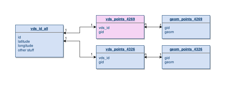
DROP table if exists tempseg.relation_direction_geometries;

CREATE SEQUENCE tempseg_relation_direction_geometries_seq increment by 2;

SELECT rr.id as relation_id,sequence_id,linestring,
nextval('tempseg_relation_direction_geometries_seq') as ordering,
       CASE WHEN rr.direction = 'roles' THEN
            CASE WHEN m.member_role='' then 'any'
                 WHEN m.member_role is null then 'any'
                 --handle US:US 6, North&East, West&South
                 WHEN relation_id=337473 then
                      CASE WHEN m.member_role='east' then 'north'
                           WHEN m.member_role='west' then 'south'
                           ELSE m.member_role
                      END
                 ELSE m.member_role
            END
            WHEN rr.direction='' then 'any'
            WHEN rr.direction is null then 'any'
            ELSE rr.direction
       END as direction
into tempseg.relation_direction_geometries
FROM route_relations rr
JOIN relation_members AS m ON (rr.id=m.relation_id)
JOIN ways AS w ON ( member_id = w.id )
WHERE npoints(linestring) > 1  -- has to be a line or the st_collect breaks
-- and relation_id=69364
order by relation_id,direction,sequence_id;


-- first fix the directions of any to be all

drop table if exists tempseg.nother_table;
select rdg.relation_id,rdg.sequence_id,rdg.linestring,rdg.ordering,b.direction
into tempseg.nother_table
from tempseg.relation_direction_geometries rdg
join (select distinct relation_id,direction
      from tempseg.relation_direction_geometries d
      where direction != 'any') b on (b.relation_id=rdg.relation_id)
where rdg.direction='any';

-- Theoretically, that is every 'any' duplicated at most

-- need to make sure I handle lines that *only* have any direction?

-- then merge those

-- first the ones in 'nother_table

drop table if exists tempseg.initial_routelines cascade;
select relation_id,
       direction,
-- st_numGeometries(st_linemerge(st_collect(linestring)))
 st_linemerge(st_collect(linestring))
 as linestring
into tempseg.initial_routelines
from (
 select rdg.relation_id,
       rdg.direction,
       rdg.linestring,
       rdg.sequence_id
 from tempseg.relation_direction_geometries rdg
 where rdg.direction != 'any'
 UNION
 select n.relation_id,
       n.direction,
       n.linestring,
       n.sequence_id
 from tempseg.nother_table n
) q group by relation_id,direction;

--  now add the 'any' direction ones
insert into tempseg.initial_routelines
select relation_id,
       'both' as direction,
-- st_numGeometries(st_linemerge(st_collect(linestring)))
 st_linemerge(st_collect(linestring))
 as linestring
from (
 select rdg.relation_id,
       rdg.direction,
       rdg.linestring,
       rdg.sequence_id
 from tempseg.relation_direction_geometries rdg
 where rdg.direction = 'any' and
       rdg.relation_id not in (select distinct relation_id from tempseg.nother_table)
) a
group by relation_id, direction;

-- okay, now clean up those multilines


drop table if exists tempseg.route_relations_split_lines cascade;
CREATE TABLE  tempseg.route_relations_split_lines (
  relation_id bigint not null,
  direction text,
  id4 serial primary key,
  segment_id int not null
);
SELECT AddGeometryColumn( 'tempseg','route_relations_split_lines', 'routeline', 4326, 'LINESTRING', 2);

-- truncate tempseg.route_relations_split_lines;
insert into tempseg.route_relations_split_lines
 (relation_id,direction,segment_id,routeline)
SELECT
  relation_id,direction,generate_series(1,(Select ST_NumGeometries(linestring))*2,2) as segment_id,
ST_GeometryN(linestring, generate_series(1, ST_NumGeometries(linestring))) AS routeline
FROM tempseg.initial_routelines
where ST_NumGeometries(linestring) is not null
-- and  relation_id = 70350
order by relation_id,direction
;

--  select distinct relation_id from tempseg.route_relations_split_lines order by relation_id;
--  relation_id
-- -------------
-- --        70350
-- --       74660
-- -- skipping       74885
-- --       76279

-- I did those above 4 on OSM, and all of them were off ramps attached
-- to the main relation, or wrong way segments.  So try this...just
-- drop all short segments

-- select relation_id,direction,segment_id,
--  st_length_Spheroid(
--      routeline,
--      'SPHEROID["GRS_1980",6378137,298.257222101]') as llength
-- from tempseg.route_relations_split_lines
-- where relation_id in  (70350, 74660, 74885, 76279)
-- order by relation_id,direction,llength;

-- so, first try getting rid of lines under 500 meters

drop table if exists tempseg.fixed_relations;

select relation_id,direction
into tempseg.fixed_relations
from (
select GeometryType(st_linemerge(st_collect(routeline))) as geomtype,relation_id,direction from tempseg.route_relations_split_lines
group by relation_id,direction
order by geomtype
)a where geomtype = 'LINESTRING';

-- manually ratchet up the length from 100 to 1000, I guess


delete from tempseg.route_relations_split_lines
where
(st_length_Spheroid(
     routeline,
     'SPHEROID["GRS_1980",6378137,298.257222101]')) < 200
;

insert into tempseg.fixed_relations (relation_id,direction)
select relation_id,direction
from (
  select GeometryType(
          st_linemerge(st_collect(routeline))) as geomtype,
         relation_id,direction
  from tempseg.route_relations_split_lines
  left outer join tempseg.fixed_relations q using(relation_id,direction) where q.relation_id is null
  group by relation_id,direction
  order by geomtype
)a where geomtype = 'LINESTRING';

delete from tempseg.route_relations_split_lines
where
(st_length_Spheroid(
     routeline,
     'SPHEROID["GRS_1980",6378137,298.257222101]')) < 400
;

insert into tempseg.fixed_relations (relation_id,direction)
select relation_id,direction
from (
  select GeometryType(
          st_linemerge(st_collect(routeline))) as geomtype,
         relation_id,direction
  from tempseg.route_relations_split_lines
  left outer join tempseg.fixed_relations q using(relation_id,direction) where q.relation_id is null
  group by relation_id,direction
  order by geomtype
)a where geomtype = 'LINESTRING';

delete from tempseg.route_relations_split_lines
where
(st_length_Spheroid(
     routeline,
     'SPHEROID["GRS_1980",6378137,298.257222101]')) < 600
;

insert into tempseg.fixed_relations (relation_id,direction)
select relation_id,direction
from (
  select GeometryType(
          st_linemerge(st_collect(routeline))) as geomtype,
         relation_id,direction
  from tempseg.route_relations_split_lines
  left outer join tempseg.fixed_relations q using(relation_id,direction) where q.relation_id is null
  group by relation_id,direction
  order by geomtype
)a where geomtype = 'LINESTRING';

delete from tempseg.route_relations_split_lines
where
(st_length_Spheroid(
     routeline,
     'SPHEROID["GRS_1980",6378137,298.257222101]')) < 800
;

insert into tempseg.fixed_relations (relation_id,direction)
select relation_id,direction
from (
  select GeometryType(
          st_linemerge(st_collect(routeline))) as geomtype,
         relation_id,direction
  from tempseg.route_relations_split_lines
  left outer join tempseg.fixed_relations q using(relation_id,direction) where q.relation_id is null
  group by relation_id,direction
  order by geomtype
)a where geomtype = 'LINESTRING';

-- select GeometryType(st_linemerge(st_collect(routeline))) as geomtype,relation_id,direction from tempseg.route_relations_split_lines
-- left outer join tempseg.fixed_relations q using(relation_id,direction) where q.relation_id is null
-- and id4 not in
-- ( select id4
--   from tempseg.route_relations_split_lines
--   where  (st_length_Spheroid(
--      routeline,
--      'SPHEROID["GRS_1980",6378137,298.257222101]')) < 900
-- )
-- group by relation_id,direction
-- order by geomtype;


-- okay, that has pretty much run out of its usefulness.  Now I need
-- to insert segments as needed.  My thought is for those geoms with
-- two or three parts, make segments to join the parts, if that
-- segment is less than 1km

-- how?

-- select geometry 1 of N, last point, join with first point, geometry 2 of N

-- so make a new temp table

drop table if exists tempseg.more_split_lines cascade;
CREATE TABLE  tempseg.more_split_lines (
  relation_id bigint not null,
  direction text,
  id4 serial primary key,
  fix boolean default false,
  segment_id int not null
);
SELECT AddGeometryColumn( 'tempseg','more_split_lines', 'routeline', 4326, 'LINESTRING', 2);


insert into tempseg.more_split_lines
 (relation_id,direction,segment_id,routeline)
SELECT
  relation_id,direction,generate_series(1,(Select ST_NumGeometries(linestring))*2,2) as segment_id,
ST_GeometryN(linestring, generate_series(1, ST_NumGeometries(linestring))) AS routeline
from (
  select st_linemerge(st_collect(routeline)) as linestring,
         relation_id,direction
  from tempseg.route_relations_split_lines
  left outer join tempseg.fixed_relations q using(relation_id,direction)
  where q.relation_id is null
  group by relation_id,direction
) b
where ST_NumGeometries(linestring) is not null;


-- self join, construct joining segments

insert into tempseg.more_split_lines
  (relation_id, direction, segment_id, fix,routeline)
  select rl1.relation_id, rl1.direction,rl1.segment_id + 1 as segment_id,
       true as fix,
       st_makeline(
             st_endpoint(rl1.routeline),
             st_startpoint(rl2.routeline)
       ) as routeline
  from tempseg.more_split_lines rl1
  join tempseg.more_split_lines rl2
       on (rl1.relation_id=rl2.relation_id
           and rl1.direction = rl2.direction
           and rl1.segment_id + 2 = rl2.segment_id
          )
  where not ST_equals(st_endpoint(rl1.routeline),
             st_startpoint(rl2.routeline))
  and ST_Distance_Sphere(st_endpoint(rl1.routeline),
             st_startpoint(rl2.routeline)) < 1000
;

-- select  GeometryType(st_linemerge(st_collect(routeline))) as geomtype,
--        relation_id,direction
-- from tempseg.more_split_lines
-- group by relation_id,direction
-- order by geomtype;

-- Okay, that is as good as I can get for now

drop table if exists tempseg.revised_route_lines cascade;
CREATE TABLE  tempseg.revised_route_lines (
  relation_id bigint not null,
  direction text,
  id4 serial primary key,
  unique (relation_id,direction)
);
SELECT AddGeometryColumn( 'tempseg','revised_route_lines', 'routeline', 4326, 'GEOMETRY', 2);


insert into tempseg.revised_route_lines
(routeline,relation_id,direction)
select  st_linemerge(st_collect(routeline)),
       relation_id,direction
from tempseg.more_split_lines
group by relation_id,direction;

insert into tempseg.revised_route_lines
(routeline,relation_id,direction)
select st_linemerge(st_collect(routeline)),
       relation_id,direction
from tempseg.route_relations_split_lines
join tempseg.fixed_relations q using(relation_id,direction)
group by relation_id,direction;


insert into tempseg.revised_route_lines
(routeline,relation_id,direction)
select linestring,relation_id,direction
from tempseg.initial_routelines
where geometrytype(linestring)='LINESTRING';

After

revised_route_lines/sqitch.plan

%syntax-version=1.0.0
%project=revised_route_lines
%uri=https://github.com/jmarca/revised_route_lines

tempseg_schema 2016-04-14T23:38:28Z James E. Marca <james@activimetrics.com> # schema for temp segment work
rdg_seq [osm_via_osmosis:route_relations] 2016-04-14T23:24:30Z James E. Marca <james@activimetrics.com> # sequence for relation direction geometries table
rdg [tempseg_schema rdg_seq] 2016-04-14T23:44:06Z James E. Marca <james@activimetrics.com> # relation-direction-geometries utility table
initial_routelines [tempseg_schema rdg] 2016-04-15T00:00:11Z James E. Marca <james@activimetrics.com> # initial_routelines utility table
split_lines [initial_routelines] 2016-04-15T05:01:17Z James E. Marca <james@activimetrics.com> # first split lines table
fixed_relations [split_lines] 2016-04-15T05:22:29Z James E. Marca <james@activimetrics.com> # fixed split relations
more_splits [fixed_relations split_lines] 2016-04-15T06:28:42Z James E. Marca <james@activimetrics.com> # more split lines working table
rsl [more_splits fixed_relations split_lines] 2016-04-15T06:43:41Z James E. Marca <james@activimetrics.com> # revised route lines

revised_route_lines/deploy/rsl

-- Deploy revised_route_lines:rsl to pg
-- requires: more_splits
-- requires: fixed_relations
-- requires: split_lines

BEGIN;

CREATE TABLE  tempseg.revised_route_lines (
  relation_id bigint not null,
  direction text,
  id4 serial primary key,
  unique (relation_id,direction)
);
SELECT AddGeometryColumn( 'tempseg','revised_route_lines', 'routeline',
                          4326, 'GEOMETRY', 2);

INSERT INTO tempseg.revised_route_lines
            (routeline,relation_id,direction)
SELECT
        ST_linemerge(ST_collect(routeline)),
        relation_id,direction
FROM tempseg.more_split_lines
GROUP BY relation_id,direction;

INSERT INTO tempseg.revised_route_lines
            (routeline,relation_id,direction)
SELECT ST_linemerge(ST_collect(routeline)),
       relation_id,direction
FROM tempseg.route_relations_split_lines
JOIN tempseg.fixed_relations q USING(relation_id,direction)
GROUP BY relation_id,direction;


INSERT INTO tempseg.revised_route_lines
            (routeline,relation_id,direction)
SELECT linestring,relation_id,direction
FROM tempseg.initial_routelines
LEFT OUTER JOIN tempseg.revised_route_lines rrl using(relation_id,direction)
WHERE geometrytype(linestring)='LINESTRING'
AND rrl.relation_id IS NULL;

COMMIT;

Example test

PREPARE tallyup AS
   SELECT count(*)::integer
   FROM tempseg.route_relations_split_lines;

PREPARE this_or_that AS
   SELECT CASE
            WHEN exists(SELECT tablename
                        FROM pg_tables
                        WHERE schemaname='tempseg'
                          AND tablename='fixed_relations')
            THEN 1884
            ELSE 2799
            END;

SELECT results_eq('tallyup', 'this_or_that',
                  'The data got loaded okay');

Sqitch and pgTAP are great

“Itches”

  1. verify != test
    • I want to put pgTAP tests into the verify scripts
    • Instead, need to write SQL that will fail
  2. Dependencies are checked at deploy time
  3. Can’t automatically deploy dependencies

My plans

  • npm run-scripts to deploy, verify, test
  • npm run-scripts to fetch dependencies
  • npm run-scripts to deploy dependencies
  • stop using mocha; switch to node-tap

Thank you